Over 500 miles of trails

Someone said that there are over 500 miles of trails in Marin County. I'm going to hike all of them. Want to hear more? Read on...

Name:
Location: Woodacre, California, United States

Well, I hike, obviously. I read, without retaining, lots of stuff but mostly classic and contemporary fiction, history, and science. I look at birds and plants. I play my guitar far less than I ought, and watch movies far more. I like to ask people questions, but only if they ask me questions in return. I aspire to honorable behavior and am mostly successful. I'm on the cusp of a career change, with bird research in my past/present and academic librarianship in my future. Occasionally I bust out and cook six course gourmet meals for my friends; for some reason it's always six and never seven or five. Enough about me. What about you? Stranger or friend, drop me a line!

Monday, May 29, 2006

In addition to lobotomizing my yellow shirt yesterday, I went hiking. Arty and I went on a hike that I've been eyeing for a long time. I've been eyeing it for so long that it became a bit of a bete noir in my mind, you know how you build things up over time? And then they aren't nearly as big a deal as you thought they would be. Don and Kay Martin of _Hiking Marin_ describe it as 'strenuous but spectacular'. The elevation gain is around 2100', not all at one go but rather dispersed throughout the hike, as the trails traverse several ridges with only a slight attempt to follow contour lines. So I thought I was in for a killer, but actually it wasn't really that bad. The distance was around 8.5 miles, all told... hard to say exactly since there are a couple of inconsistencies in distances in the book and the map.

The hike is a lollipop: a loop with a trail coming off it to from/to the trailhead. The crowning glory and most challenging section of the hike was the stick of the lollipop, the Cataract Trail, which starts near Alpine Dam on the Bolinas-Fairfax road. Cataract Trail follows the shores of Alpine Lake for a brief spell, then climbs the steep drainage of Cataract Creek, which cascades down a rocky gully with many smallish drops and a couple of falls around 30' or so. So all the way up the trail, pleasing waterfalls distract you from your toil and offer ample opportunity to stop and admire/catch your breath.

Cataract Trail is joined by the Helen Markt trail (the return route on the loop) at around .6 miles, and continues along the drainage of the creek, levelling out a bit. I encountered more fledgling winter wrens (here's an adult winter wren- they're generally darker in redwood forests, probably because they get less sun) on this section of trail; one landed right between my feet. I admired it for a second or two before realizing that, if it caught Arty's attention, it would be a goner for sure. So I moved onward, climbing toward Laurel Dell, a picnic area at 1640' near Ridgecrest Boulevard, the auto route up Mt. Tam.

Short jaunts on the Laurel Dell fire road and Bare Knoll trail (which is a slightly more roundabout but worthwhile route because of its views out toward the ocean) joined me up again with the High Marsh trail. The High Marsh trail traverses some of those ridges I was talking about earlier, so there was a lot of up and down. We passed what I guessed to be the high marsh, a murky mudhole that Arty nonetheless took the opportunity to immerse himself in, and shortly thereafter took the Kent Trail steeply down through a classic redwood forest to the junction with the Helen Markt trail.

I spied not one, but two, women peeing at this trail junction. They were hiking with a group of around 8 folks and had ducked around the corner from their group to take a piss on opposite sides of the same bush. 'Peeing on opposite sides of the same bush'-- that sounds like a euphemism for something. At any rate, I grabbed Arty's collar and ducked back around the corner before either saw me and waited for a tactful interval before proceeding. I wonder how many of my outdoor urination 'near-misses' were not, in fact, misses at all?

I'm sure Helen Markt is/was a very nice person, but her trail has some significant ups and downs that weren't entirely welcome 7 miles into the hike. There's a brief view of Alpine Lake near the junction, but after that it's obscured by the forest. This was probably the least interesting part of the hike, but doing the loop as a whole was well worth this section.

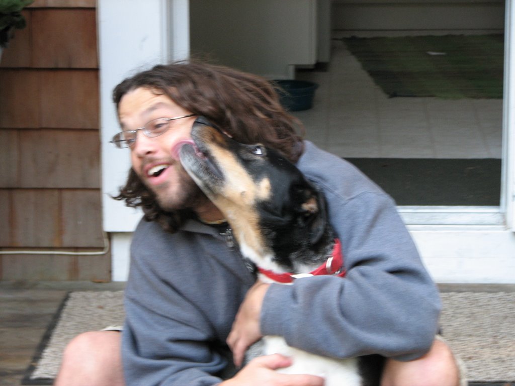
As Arty and I neared the trailhead he decided to take a plunge in the lake, which (despite rules against it- public water supply and all) I was glad of since he had rolled in something foul further up the trail (even better; rinsing off carrion in the public water supply! Not that deer, squirrels, etc don't die in streams that feed the reservoir all the time). Arty's not much of a swimmer, nor is he much of a stick man, but for some reason a post sticking out of the lake about 30 feet off-shore caught his fancy. He swam out to it and gnawed on it briefly before realizing it was attached to the bottom of the lake. He gave up and swam back. A small anecdote, but significant in Arty's biography as it's probably the furthest he's ever swam.

Drove home sticky, sweaty, dehydrated (2 liters wasn't quite enough) with Arty carrion on my hands, only to discover that the water at my house was shut off. My landpeople were working on a home improvement project only to discover vines eating the water pipe that services both their house and mine. Distressing. It was back on by that evening, though.

I got some new t-shirts last week at Target, cause it was time to stock up again. I got a purple, a red, and a yellow. The yellow was a bit of a risk. I like yellow alright, it's just that I've never really been easy around it. Yellow, in my mind, is like the stranger at your party who seems perfectly nice but who may or may not get drunk and do inappropriate or destructive things beyond your control. I wore my yellow shirt last week and felt a little bit jumpy all day. A yellow dishtowel or wallpaper is one thing, but such a color to have in close proximity to your body! Who knows what may happen?

I washed my yellow shirt yesterday. I washed it with my new red shirt, my new purple shirt, and with my green kitchen rug that's never been washed.

The yellow shirt now has a grayish tinge, just enough to put a leash on its exuberance. I think the yellow shirt and I will coexist much more peacefully, now.

Saturday, May 20, 2006

Arty and I went for a hike in Deer Park this morning. Very nice but it's awfully mountain-bikey there on the weekend. And Arty has this inconvenient characteristic where, if a mountain bike is hurtling downhill toward him and I yell "Come!" he turns and stares up the trail at the approaching mountain biker rather than coming off the trail to me. Consequently, he was on leash for the steep downhill portions of the hike.

We got on the trail a little before 8 this morning; it was still socked in with fog but very pretty. I took the Deer Park trail (off to the left once you get past the school) which climbs a steep, narrow drainage up to Worn Springs Fire Rd., which climbed Bald Hill (1141'). If I had a camera, I could have taken a comical "The view from Bald Hill" picture of the fog that was all around, but since the camera is in Alaska you'll just have to forego that wickedly clever bit of visual humor. Actually, I could see a bit off in the direction of the Bay, and I could tell that the views of the Bay and Mt. Tam must be really amazing on a clear day. Other trails lead to the top of Bald Hill as well so I'll be back again. From there I continued on down Worn Springs Rd. to Phoenix Lake, where I skirted the lake for a half-mile or so. The Phoenix Lake area was crazy busy with people, including one guy who was simultaneously fly-fishing and talking very loudly on his hands-free cell phone. His voice literally echoed across the lake, and when I say literally I literally mean literally as opposed to some folks who say literally and really mean figuratively (Wow- when you type literally that many times it starts to look really weird). Anyway, it was gross. I can't wait till I'm working part time again and can hike on weekdays. From there I continued up Shaver Grade to the Five Points Junction, where I picked up the Deer Park Fire Road back down to the trailhead. It was around a six mile hike with a good variety of habitats and some good ups and downs.

It was a nice day for good naked-eye looks at birds. I saw two horned larks on the top of the hill; I don't know if they're common around here or not but they were quite mellow. The Deer Park Trail up the canyon yielded a warbling vireo. Because the canyon was quite steep, the bird was at eye level with the trail even though he was in the treetop. And, there was a spotted towhee that just sat and sang in a shrub for around 5 minutes while I watched. This lack of a camera is becoming an issue... I could have gotten great shots of any one of these birds that I could have shown you instead of stealing other people's. Of course, Victor will have far more stirring and interesting photo ops in Alaska. But I'm seriously considering picking up a little point-n-shoot for myself that I can keep in my jacket pocket.

What else? I was thinking today about how inconvenient it is that I can't hike and blog simultaneously. I think when I'm hiking my brain is stimulated by all those good exercise endorphins and the ideas just pour forth, and I think, "Yeah! I should write about that!". But once those endorphins subside and I'm all sleepy with a bowl of pasta in me and I'm in front of the computer the stream dries up. Oh well. It's just another form of chemical alteration anyway, and wouldn't you rather have the 'real' me (because clearly the sleepy pasta-full me is much closer to my true essence than the hopped up on endorphins me)?

I just had an idea. I could get a hands-free device and blog, really loudly, as I hike. -Kelly

Thursday, May 18, 2006

Well, I haven't been posting cause I haven't been hiking. Instead I've been dorking around with my profile and other blog-associated fluff, as you may have noticed.

Underwent a slight depression last weekend due to the imminence of Victor's departure (it's actually easier now that he's gone because I don't have to dread his going anymore, though it's still lonesome). And this week and next week I'm working full-time at the behest of my boss. You see, we've got these bird banding stations all over North America that we hire interns to run (over the last four months I recruited 34 interns, but only the last 6 or so really hurt. It was kind of like that time Paul Newman ate 50 hard-boiled eggs in Cool Hand Luke). The interns are supervised by biologists and it's my job to coordinate field equipment, housing, and access to their sites for all of them. The field season just started and so everyone's calling in with lots of questions. Add this to the fact that usually there's three of us and now, with Victor and Ron (the third) gone in the field there's just one of me to do whatever random tasks are required.

But I didn't start this post to whine about my job. What I really wanted to do was to take this opportunity to acquaint you with some rules that I've decided upon for the project, so that it doesn't devolve into drudgery.

I am not including:
1.) Spur trails that are less than one mile long that have no purpose other than to allow neighborhood access.

2.) Trails that parallel other trails with a distance of less than 300 meters between them (like all those foot trails that parallel the fire roads in the Open Space parcels).

3.) Unofficial trails that are not documented on a map, sign, or in a book.

Let me know if you think I'm wussing out by imposing these limits, and I'll take your arguments under consideration, provided that they are both rational and eloquently put.

And also, just so you know, I am highlighting my maps in orange highlighter, not yellow, as I mentioned earlier. The orange shows up much better. If I had my camera I'd take a picture of one of my maps so you could see how much orange I've got so far. That'd be cool. But alas, the camera's in Alaska. It may be for the best, since hopefully by the end of the summer the amount of orange will be far more impressive to behold. Right now, of my four maps, the Point Reyes Nat'l Seashore is my most orange map by far: it's, say, 30% orange? Orange content averaged over all four maps is probably around 10% and I've been hiking around 6 months; this means I've got 54 months to go at this rate. I'd better get a move on, since I don't think I'm going to be here that long.

So I'll hike this weekend and then I'll tell you about it. And maybe I'll have to borrow a friend's camera so you can look at more pictures. Here's a random one from the archives:

Saturday, May 13, 2006

This past Tuesday I went on a solo hike in the Palomarin area of Point Reyes Nat'l Seashore. It was a long, but pretty mellow, hike... 11.2 miles but nothing too steep or gnarly.

I started from the parking lot of the Point Reyes Bird Observatory, took their little nature trail (which is rather overgrown... I'm not sure if it's just cause it's springtime or if they've stopped maintaining it) back out to the road, and from there picked up the Ridge Trail, which I followed up (strangely) the ridge for around 5 miles until I reached the Lake Ranch trail, which led back down toward the coast. The highlight of my hike was along this trail... a little tiny bomber went buzzing past me and landed in the trail, at which point I saw that it was in fact a fledgling winter wren clearly just learning to fly. He could make it about 10 feet before coming to ground again, and I watched him as he progressed forward and finally made it off the trail in four or five stages. It all looked rather tiring for him and I felt bad, but a parent was calling nearby so I felt sure that he would be fed and cared for once I left the area, which I quickly did.

Lake Ranch dumped me onto the Coast Trail, which if I had taken north would have led me to Double Point, which is apparently splendiferous, though I've never been (I shall have to go at some point). I took it south back toward my starting point to complete the loop, enjoying views of the coastal bluffs and Palomarin beach as I hiked.

I took no pictures... felt like looking at the world through my own eyes rather than the eyes of the camera that day.

So this Dixon trail issue? I read about it in the Point Reyes Light. It would be a shame if the public lost access to a trail of such length that's been in use since the 20's, but at the same time its hard on the owners to dictate to them how their land must be used. And then, of course, as it always is, the spectre of eminent domain has been raised... can anyone really justify seizing somebody's land for the sake of recreation? It's controversial enough when we talk about seizure for the sake of improving people's livelihoods or increasing a town's economic viability. Has anyone talked about the possibility of rerouting the trail? I didn't see anything about this in the article, though I was reading in the john and so was perhaps less attentive than I ought to be.

Landowners' rights aside, I suppose I had better get out there while I still can, as noted in a previous comment by aphotoaday
-Kelly

Thursday, May 11, 2006

Yarg! Victor's going away for 2.5 months on Tuesday. He's going to Alaska.

I've been thinking a lot about this, obviously. I've been worrying, actually, because we've been in a really good rhythm lately. I'm worried that his going away will wreck our momentum and we won't be able to get it back when he returns. I don't know why I think this. I just do.

I like being in a relationship, but I'm pretty good at being alone, too. In fact, I usually do more when I'm alone because lazing around the house is not very much fun unless you have someone to do it with. So I get out a lot. In terms of the project, I expect that Victor's absence will be a good thing, because often when I can't persuade Victor to go for a hike I end up hanging out at home with him rather than going on my own. Which kind of clarifies one of my worries, actually... what if I get too used to going out and doing stuff and then feel stifled when he comes back and we end up hanging around the house more often again?

We went to Ring Mountain, not this past Saturday but the Saturday before. That would be April 29, I suppose. Ring Mountain is down by Corte Madera/ Tiburon... that sort of area. Wildflowers are great there but the whole place is so small, and so heavily used, that everything looks slightly trampled. We took some pictures, and Victor took some footage with his video camera. Don't know about uploading the video, but here's some pics:


We're getting a little crazy with the macro, I know. Next time I hike I'll try to take a picture of the scenery, too.

So we pretty much hiked all the trails that there were to hike at Ring Mountain... like I said, it's a small place. Best on a clear day, definitely... views all around the Bay.


That's it for tonight. It's time for bed. I still have to tell you about the hike I did on Tuesday at Point Reyes. Later. -K