Over 500 miles of trails

Someone said that there are over 500 miles of trails in Marin County. I'm going to hike all of them. Want to hear more? Read on...

Name:
Location: Woodacre, California, United States

Well, I hike, obviously. I read, without retaining, lots of stuff but mostly classic and contemporary fiction, history, and science. I look at birds and plants. I play my guitar far less than I ought, and watch movies far more. I like to ask people questions, but only if they ask me questions in return. I aspire to honorable behavior and am mostly successful. I'm on the cusp of a career change, with bird research in my past/present and academic librarianship in my future. Occasionally I bust out and cook six course gourmet meals for my friends; for some reason it's always six and never seven or five. Enough about me. What about you? Stranger or friend, drop me a line!

Sunday, January 22, 2006

Went hiking at Roy's Redwoods today. We (me, Victor, Arty) set out to hike a loop involving Cataract Canyon, but the Bolinas- Fairfax road is closed (maybe due to lingering mudslide damage?) so we had to change our plans at the last minute. A little disappointing, but we had fun nonetheless. We pretty much 'hiked it out'... I don't think I'll have to go back to Roy's Redwoods again for this project except to pick up a Fire Road that I think connects to another Open Space area. Notable on the hike was the amount of mud and the amount of interesting fungi. We took some photos so I'll let them do the talking:


I went hiking today. But I'm still not caught up on back hikes so first I'll tell you about the hike I did on Thursday, January 19, 2006. This was another Thursday afternoon shuttle hike courtesy of the magnificent Victor. He dropped me off at the Coast Trailhead near the youth hostel at Point Reyes National Seashore at 1:15pm, with the arrangement that he would pick me up at the Bear Valley trailhead at 5:30. I hiked down the Coast trail to (strangely) the coast, stopping along the way to marvel at a large group of Townsend's warblers gleaning on a newly-flowering tree in the riparian area that I was paralleling. I also encountered a great blue heron that was reluctant to leave the drainage ditch next to the trail, and so kept jumping ahead of me by a few yards until he was finally convinced of the futility of this effort and departed for more peaceful waters.

I hiked along the coast on the Coast trail for about 3.5 miles, atop bluffs of 20-50 feet overlooking the ocean. I kept my eye out for whales, since it's that time of year, but no luck. I kept encountering other solo female hikers, which made me feel good... I don't know why, exactly. Rested at a picnic area that had a large group of California quail that appeared quite used to humans, though they scattered when one of the omnipresent soaring turkey vultures imitated a falcon and briefly went into a stoop. Continuing onward, I reached the junction of the Coast and Woodward trails, and started upward. The Woodward trail is a bit steep... I think I climbed around 1200 feet in 1.8 miles, and most of that was in the first mile or so. But it's a great trail- it might be my new favorite. As you switchback across the hillside, you earn ever wider views of Chimney Rock to the northwest and Sculptured Beach to the southeast. Eventually, the trail brings you into a recently burned area... I'm not sure if it was burned at the same time as the Mt. Vision fire or not... it's not super close to the Mt. Vision area. The burned area was very picturesque, with stark black skeletons of trees standing out against burgeoning greenery. Woodward Trail dumps you out at Sky Trail. I had been on this segment of Sky Trail last week, so as far as my goal went it was a waste of a mile or so. I didn't particularly care. Took the Wittenburg trail and realized, by the sun, that once again I was way early for meeting Victor at the visitor center. So I relaxed for a bit at the junction of Wittenburg and Z Ranch trails and plotted future hikes with my book and map.

The Wittenburg trail back down to the Bear Valley trailhead was nice... nothing spectacular, just more of your good, basic, hilly Doug fir/ bay forest terrain. But this was fun... I encountered a couple having a domestic squabble coming up the trail. They were audible a good 100 yards away, or so, and didn't realize I was there until they had nearly bumped into me. The woman was screaming at the man that he never supported her, that she wanted to hike alone, and that she needed an IPod. Wheeeee! It's always gratifying to encounter evidence that supports my general impression that the rest of the world is more screwed up than myself. At least they had the grace to look embarrassed when they registered my presence.

For balance, I met a wise-seeming, calm, interesting older man as I was coming into the visitor center parking lot and we chatted briefly. He's been hiking in Marin since the early 80's and I think he was slightly amused by my notion of hiking all the trails in Marin County, but was encouraging nonetheless. Perhaps I'll see him again on some other hike.

Victor picked me up and that was the end of a quite satisfying hike. I think it was just shy of 9 miles, all told.

Saturday, January 21, 2006

I'm starting to get caught up. I haven't consumed anything except orange juice all morning. At least it's not coffee. Though I'd probably be funnier if it were.

On Thursday, January 12, I went for a fantastic hike after work. But before I tell you about that, let me tell you about this: the best thing about my job is that I only have to be there 30 hours a week. Other than that, it really doesn't have much going for it. Sure, some of the people are nice, but everything I do is either boring or annoying. But, my point is that the 30 hr/week schedule allows me to work 3 eight-hour days and one 6-hour day. And then I'm done. So on Thursdays I work from 6 am till 12pm. Since my work is in Point Reyes Station, I'm mere minutes away from great hiking in the Point Reyes National Seashore, and I can get in good half-day hikes.

At any rate, last Thursday my dear Victor (who works at the same place I do) was kind enough to drop me off at the Sky Trailhead on the road out to Limantour at 12:30 or so. I hiked about 8.7 miles that day, give or take. I hiked the Sky Trail about 5.5 miles to the Baldy trail, then one mile down to the Bear Valley trail, 3.2 miles back to the Bear Valley Visitor Center, where Victor picked me up at 5pm. I had originally planned to take the Old Pine Trail down, but that would have been way too short... I would have been back to the Visitor Center at 3:30 or so. And, I would have missed the best part of Sky Trail. The trail follows a ridge that angles southeast toward the south-facing coast of Point Reyes. For much of the trail the forest is too dense to see much of the coast, but at one point you hike up a gentle grade toward a notch, below which the land falls away from you and you have a great view of the ocean and the bluffs along the shoreline facing southeast. It was a partly cloudy day and the sun hit the gray water through holes in the clouds, creating brilliant patches of reflected sun amidst the gray.

Hiking back along the Bear Valley trail there were signs all around that Coast and Bear Valley Creeks had flooded considerably during the New Year's Day storms... debris had been deposited several feet above the banks of the creeks. I saw a feral cat and a bunch of white deer in Divide Meadow, which marks the division between the Coast and Bear Valley Creek watersheds. I tried really hard to make the feral cat into something cooler, like a bobcat, but I'm pretty sure it was just a feral cat, since it had a tail.

I like being dropped off for my hikes. It makes me feel independent to be out there with no vehicle to return to, knowing that I have to cover a certain amount of ground if I'm to meet up with my ride. No chance of backing out.

For some bonus material, I'll tell you about the mini-hike that Victor and I went on that Saturday, January 14. It was more of a birding expedition, really, because on the 12th someone had spotted a Eurasian wigeon (that's a kind of duck not commonly seen round these parts) at the Rush Creek Open Space preserve). So we lugged spotting scope, camera, and binoculars round the trails at the Marin Audubon land near Rush Creek. It was a drizzly, dreary day but the birds were out in force. We did not spot the Eurasian wigeon, but we did see plenty of American wigeon as well as scaup, bufflehead, goldeneye, and other fun stuff. Landbirds that we haven't seen much of elsewhere included oak titmice and ladder-backed woodpecker. Only hiked a mile or two on the trails, but it was good-n-birdy nonetheless.

-Kelly

A Saturday in December-- I don't remember which one

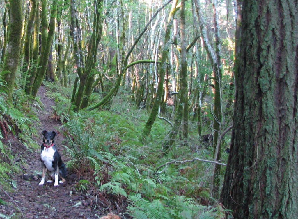
Did a short hike (4 miles, maybe?) at the Mount Burdell Open Space. Mount Burdell is a lovely, open oak savannah hilly sort of place, tucked up behind the housing developments west of San Marin Ave, in Novato. Despite the feeling that you're never more than .5 miles from a BMW at any point in the hike, there's a pretty nice diversity of bird life there. There's an abundance of lark sparrows at the right time of year (apparently not December, but I've seen them there spring/summer). I've been there a lot, so this wasn't much of a 'discovery' hike. It was mostly a 'get Arty out of the house' hike, in which it succeeded admirably.

Hiked up the San Marin Fire Road, to San Carlos, around the Salt Lick Fire Road, up to Middle Burdell, down San Andreas Fire Road back to the car. It was an easy hike but I was feeling subenergetic. Dehydrated, probably.

Well, other than that stirring account, I don't have much else to say about that hike. I guess now's as good a time as any to give cred to the resources I've been using.

I have four maps:

Trails of Northeast Marin County-- this is by Ben Pease and a fine quality sort of map it is. He has a website from which you can order his maps and check out his other, interesting activities. This map mostly depicts the several Open Space parcels around Novato and San Rafael.

Southern Marin Trail Map and Mt. Tam Trail Map-- are by Tom Harrison. They're smaller, a nice size for hiking, and depict trails in areas that I didn't even know existed. My work is cut out for me, I guess. I ordered these, and the above map by Ben Pease, off of www.boredfeet.com, a cool small press that features a range of California guide books and hiking-related accounts and memoirs.

Point Reyes National Seashore and West Marin Parklands. Published by Wilderness Press, I purchased it in the Bear Valley Visitor Center at Point Reyes National Seashore. Covers an extensive chunk of West Marin; not just the National Seashore but areas of the Golden Gate NRA and Samuel P. Taylor State Park.

Mapping trails would be fun. Maybe I'll make a third career of that, once I start and finish my second career, that of an academic librarian.

And, I am using one book:

_Hiking Marin: 133 Great Hikes in Marin County, 2nd ed._ by Don and Kay Martin, published by Martin Press in 1999. This book rocks. Hikes are rated by difficulty and aesthetic quality, and the book includes lists of best hikes by time of year, best waterfall hikes, best view hikes, etc., as well as a little thumbnail wildflower, bird, and ecosystem guides. And the maps accompanying each hike are great... I've not yet been led astray. High quality work. Everyone in Marin County already knows about it, it seems, and it's widely available in local bookstores, so I'm probably not telling anyone anything new. But still, I must give credit where credit is due.

What else? I was browsing around other blogs this morning and came across one: Airplane Journal: Hiking the San Francisco Bay Area. Well, I must admit it exacerbated my inferiority complex regarding this blog. He's got sweet pictures, better writing, and his hikes are more hard-core. Must work harder.

-Kelly

Forgive me, father, for I have sinned. It's been three hikes since my last post. Hello. I'm back.

I think the problem is that I want too badly for this to be good. And since I feel like, so far, it's rather mediocre, I've been loathe to return to it. My response to not achieving a certain level of excellence is not to try harder, but to restrict myself to activities where I can be guaranteed success. Which runs counter to the whole reason why I started the project in the first place. I don't think I've mentioned this yet. I read an article in _Psychology Today_ (which I never read but happened to pick up) that talked about 'grit'. You know, persistence, doggedness, the ability to see things through to the bitter end. The article was mostly geared toward how you develop grit in your moldable, teachable child. It doesn't tell you how to develop grit as an after-market add-on once you've already been firmly ensconced in your lazy-ass, dilettante-ish ways, which, of course, is the boat I happen to be drifting aimlessly along in. I've accomplished some things in my life, sure, but I've also started a lot of things that I haven't finished, and I've given up on a lot of stuff when it became inconvenient to carry on. So I cast about for the idea for this long term project, and I think that I've already told you that Victor and I came up with this.

And I've been doing pretty well with the hiking side of it, because it's tangible and easy to measure your progress. I've purchased maps that pretty well cover Marin County, and I highlighted all the trails that I've been on so far. I've got a long way to go, but I think I've made a good start. The holidays, and the week after, were pretty slack because I was gone, and it was rainy (perhaps you heard about the flooding and the mudslides? Marin and Sonoma counties were amongst the hardest hit.) But the blogging is hard to find inspiration for. Do I merely travelogue my hike, the mileage, and the predominant relief and ecosystems through which I travel? Do I write about what I'm thinking? I feel that my blog lacks cohesion, that I've gone off the rails a bit even before I've started. So I have to work harder at finding it. And maybe that will earn me a few points on the 'grit' scale. I was only a 3 out of 5 on the _Psychology Today_ self-test.

Next post: More hiking!

-Kelly